We had booked the smallest available size (compact) and the rental agent tried to convince me that an upgrade would be ideal, but I held out and was then very pleasantly surprised to see that our 'compact' class car was actually a Honda CRV! We tackled the LA traffic head on which was crawling speed along the highways, as we headed north out of the city on a 5 hour drive to Panamint Springs. A place located on the western fringes of Death Valley National Park.
Once we were out of the city itself we travelled through a scenic and dry mountain range, only sparsely covered with small scrub-like plants. The area was a lot more barren than I had expected and we soon learned that Southern California was currently enduring a 16 year drought. We passed over the edge of the hills and headed through the flats running perpendicular to the Sierra Nevada mountain range. Included amongst this range is Mt Whitney, the highest point of the lower 48 states at 4,417m above sea level. What made this more interesting was that Badwater Basin, less than 2 hours away and one of our planned stops the following day. It is the lowest point in the lower 48 states!
We pulled over at a small parking lot to admire the flat expanse over towards the surrounding northern mountains. The view was spectacular providing a great panorama shot. It was also very interesting to learn that this whole area had once been swampy wetlands many millions of years ago.
The final hour down to Panamint springs brought many more scenic viewpoints over amazing canyons, as we wound our way down to the valley floor. Some of these viewpoints included Crowley Vista which provided a great vantage point right down to the salt flats below.
We arrived at Panamint springs at about 5pm. We were a little surprised that rather than the small town we had envisioned, the whole place consisted of a petrol station, a campground and a small restaurant! It was quite exciting to spot a coyote running through the 'town' illuminated by our headlights as we pulled over to check in. We then utilised a small permanent tent in the campground for the night as well as dinner and a few local drinks at the restaurant. Then it was time to settle in for a good nights rest in order to prepare ourselves for a big day of exploring the valley.
As we only had one day to explore the valley, we decided on a North to South approach, hitting all of the major highlights before finally crossing over to Nevada for the night. It promised to be a big day but we were already excited by what we had seen so far and were packed and ready to hit the road at 8am the next morning. It helped that we were still operating on New Orleans time which was a 2 hour difference in our favour! We drove along the long straight road, crossing the first salt basin which gave us the opportunity for some amazing shots of the road and surrounding mountains with minimal traffic, before driving up and over the pass in to the primary valley itself.
Death Valley was named in 1849 by gold rush prospectors after 13 pioneers perished in the harsh conditions while trying to cross the valley. The scalding temperatures run nearly year round and even on this early October day the temperatures were sitting at around 100 degrees Fahrenheit (38 degrees Celsius). Our first port of call was the Mesquite sand dunes, looking a little odd and out of place occupying their relatively small section of the valley. In truth it looked like somebody had scooped up a section of the Sahara desert and deposited it smack bang in the middle of several mountain ranges that provided a very photogenic backdrop.
Once we had parked our car and set out into the dunes on foot, it was obvious that the area covered by nothing but sand was deceptively large. It was easy to lose yourself amongst the massive dunes and you soon felt like you could be the only people out there, despite having seen all the cars already parked in the lot. We climbed several dunes and snapped some pictures before heading back to the car and making our way to the next stop on our little road trip.
We had entered the park at approximately the middle point and needed to head around 75km north in order to reach our next destination, Ubehebe crater. Afterwards we knew that we would be turning round and driving back past the dunes on our way south but from the research we had done it would be worth pursuing the 3 hour round trip. Once we arrived at the crater we were certainly not disappointed. The size and patterns were incredible.
We were very interested to learn that this crater had not been caused by meteorite strike, as we had speculated, but instead by underground magma bubbling to the surface and exploding violently. We hiked a short half mile trail to a viewpoint overlooking the crater from the west. A hike that was made more difficult than expected by a strong breeze that had started to blow up with the occasional gust threatening to push us in to the crater itself! Sadly due to our time constraints we didn't have enough time to circumnavigate the entire crater (roughly a 3 mile walk), but we got back on the road very satisfied with our choice to make the detour North.
After a couple of hours heading southwards through the valley we arrived at Furnace Creek, the main town/tourist hub of Death Valley. Despite the dry and barren surrounds the town did boast and extremely green and luscious looking golf course which looked very out of place! We had a quick bite to eat in one of the small diners before our third major landmark of the day, Golden Canyon.
Golden Canyon consisted of a 3 mile (5km) return journey hike through an old riverbed flanked by huge brightly coloured rock formations. This truly was a wondrous place and due to the heat most tourists did not attempt it, which meant we had large portions of trail to ourselves. At times we felt like we were trekking on a distant plant from Star Wars, such were the amazing and unique sights round each corner.
The end point of the trail was a rock formation known as the Cathedral. The heat grew as we hiked along the canyon floor and we were covered in sweat by the time we made it to the end viewpoint. It was around this time as well that we started to regret leaving our water bottles back in the car!
The Cathedral itself was a very impressive sight, with the bright red rocks lifting to create spires and towers that did resemble what you would see on an historic church. After a quick scramble up a side dune for some panoramic views, we headed back to the carpark and guzzled down the liquids we had remaining in our water bottles. With temperatures like these it was very easy to believe that Death Valley holds the record for the highest accurately measured world temperature of 134 degrees Fahrenheit (57 degrees Celsius), recorded in July of 1913. By these standards, this was just a pleasant autumn day!
We backtracked down the road slightly to buy some more water in Furnace Creek, before moving onwards to our next stop, the Artists Palette. This was an small 8 mile driving loop that branched away from the main highway. Along the loop were glorious vistas showing a multitude of varying colours covering the nearby hills.
It did indeed resemble a giant paint board with many colours of the rainbow being mixed in together. Some colours were along the lines of what you expect to see, varying reds and browns, but due to the rich mineral layers in the local rocks, there were also some spectacular whites and greens to be seen.
We did attempt a short hike up to a lookout but the strong winds from earlier had progressed in to a full on gale and it was difficult to keep ourselves upright let alone try to get a good look at the hills! The wind was so strong that at one point it blew the sunglasses right off my face! We retreated from the winds and continued South to the sight that is regarded as the number 1 attraction in Death Valley, Badwater Basin.
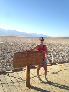
The Basin is the lowest point in mainland America with the flats sitting 84 metres below sea level. The sea level marker was painted on the cliffs overhead which drove home how low we currently were. When there is any rain in this general area the rainwaters naturally run to this point, where they start baking in the high temperatures. Evaporation comes in to play and soon all that is left behind is the minerals that were contained in the rain, most notably salt.
The repetition of this process over long periods of time has left the surrounding area covered with small salt formations, all rock hard and unique. These formations run on along the valley floor for as far as the eye can see resulting in quite an impressive sight.
Having said that, we were surprised to see a couple of small pools of water that do beat the odds and remain year round. These pools are actually the reason for the name 'Badwater Basin'. At some point in history an early explorer rode to the area and was amazed to find water in the scorching conditions. He tried to get his tired horse to drink, but no matter what he did the horse refused to go near the salty water. Hence the deduction that it must be 'bad water'. Amazingly there is life in this salty environment and as such, we were advised not to go out on to salt formations around the pools due to an endangered and endemic snail species!
The sun was just starting to touch the peaks of the mountains to the west and we knew that we still had a good 3 hours ahead of us on the road to Las Vegas. We jumped back in the car and continued to head towards the southern exit of the park. We still had one unexpected sight to see though, a couple of wild coyotes were out and about just off the road including one very friendly fellow who approached the car as if he expected us to hand out some food. No doubt previous travellers had done just that! We were very satisfied with our massive day in the valley and we headed onto our next adventure, Las Vegas!
Adrian.


